Parish Council Accounts – March 2012
 Town and Parish Council Websites
Annual Parish Meeting 2012 Minutes
You can download a copy of these minutes here (PDF file).
Broomhaugh & Riding Parish Council
Annual Parish Meeting, held on 12th May 2011 at 7.30pm in the Parish Hall, Millfield Road
Present: Cllrs Mills (in the Chair), Reid and Eakins. County Councillor Anne Dale was present with 11 members of the public including Mrs Linda Shepherd for the VHT and Ms Jen Stephenson for the First School. One member of the public made a brief appearance towards the end of the meeting.
1. Welcome and Apologies: Cllr Mills welcomed all present and reported that Cllr Dunhill had offered his apologies.
2. Cllr Reid gave a demonstration of the use of electricity monitors. It is hoped that members of the public will avail themselves of these monitors which can be borrowed, with a surety of £5, so that energy expenditure levels can be checked in homes and offices to help identify potential economies.
3. The minutes of the APM of 2010 were approved.
4. Chairman’s Report:
She commented on the busy year – due partly to the low number of Councillors – and thanked the Councillors for their work and also other members of the village for the help given to the Council. She referred to the Millfield Road bridge and the decision of the County Council (now made permanent) to impose a weight limit of 3 1/2 tonnes. She reported that the Parish Council had obtained and was publishing a survey of work to be carried out on the bridge both immediately and also in the long term.
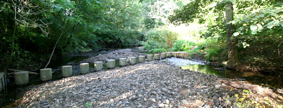
The Council was considering alternatives in respect of the Marchburn weir. These included no action, expensive restoration of the weir and reduction of the weir in either one or two stages. The Council had been advised by the director of the Tyne Rivers Trust and a member of the Environmental Agency at a meeting attended by some of the riparian owners and would give further consideration to the implications as to cost and liability of reducing the weir by 30 cm.
The Council had submitted a revised planning application for a smaller car park at the village hall, reducing the loss of amenity grass area beside the hall, which was used for village activities and weddings etc
The Spinney, ie the little wood opposite the Church, which belongs to the Council, had been opened up by cutting back weeds, and tree stumps. A path had been covered in wood chippings to suppress weeds. The suggestion that a path through the Spinney be used to enable schoolchildren to walk to school from the Old Playground had been dropped.
The Council had been concerned that some of the traffic passing through the village appeared to exceed the speed limit, endangering people crossing the main road near the corner of the Wellington. The Council therefore decided to install two interactive solar powered speed warning signs as a reminder when a vehicle exceeded the speed limit one at the foot of Whiteside for West bound traffic) C. Cllr Anne Dale kindly offered to provide much of the funding from her County Council allowance.
The Council had asked the County Council to re-site the existing sign at the main road entrance to Millfield Road and to provide a second sign to improve visibility to a driver turning into the road. It wished the double yellow lines at the east end of Church Lane . and at the main road end of Millfield Road to be extended. The Council had asked the County Council to install a new street light at the west end of Millfield Road bridge.
The newly installed mirror at the exit to Hollin Hill Terrace that had been stolen and the mirror at the foot of Sandy Bank had both been replaced.
The playpark was monitored on a weekly basis; bushes between the single tennis court wire netting and the playpark had been severely cut back. Although the damage from moles continued throughout 2010, the position in 2011 had been better.
The planning group of the Council had considered 22 planning applications during the year and its recommendations had been reported in the minutes of the Council meetings
The following policies had been introduced and approved during the year, (a) a Covenants policy (b) a formal complaints policy for any member of the village not satisfied with the way the PC had handled a particular matter and (c) a vexatious correspondence policy to enable the PC to attend to its work without entering into repetitious correspondence.
The Chairman concluded with the comment that the Councillors had given a considerable amount of time and thought to the work of the Council, but were aware that some of the decisions reached may not have pleased all members of the Parish. She reminded the village that If they were not happy with the work, they should apply to join the PC and contribute to the decision making.
There was some discussion from the floor on the Chair’s report, much of which had already taken place at the recent Council meeting concerning the survey on the bridge, the problem of emergency vehicles having access to Marchburn Lane and the priority of bridge repairs versus Weir repairs. One member of the public agreed however that the Council should be looking after the interests of the whole village and not those of a few residents.
5. Cllr Dale’s report:
She reminded people that she was responsible for Mickley, Stocksfield and Riding Mill. The cuts of £45 million to the revenue budget were causing great problems to service deliveries. She mentioned concerns about grit bins in the snow, flooding on the Corbridge road and potholes being slowly repaired. She was concerned about speeding and would contribute £4, 500 towards flashing speed signs. She was working with the Sandy Bank residents to improve access/egress at the Nick. She is contactable by email and phone but has to fit responses into County policies. Locally, major concerns are school buildings and hospitals.
Cllr Dale was thanked for always attending meetings and helping whenever she could.
6. The Financial report was circulated for information. There were no questions.
7. Broomhaugh C of E First School Report:
There are 65 in the school at present with a full quota coming into reception this Autumn. Improvements to and maintenance of the buildings were a high priority with funding affected by the cuts. The school was only closed 2 days during the snow. The PTA remains very active, helping with school trips and buying books in particular. The Squirrels Club is essential but again, funding remains tight. Support teams for special needs children have been severely affected but there is a low impact in Riding Mill. 41% of the children are from inside the village. The Church school admissions policy prioritises siblings, then Church and then the catchment area. Of the 65 children, only 16 bring packed lunches. The furthest child comes from Prudhoe and others are from Healey, Whittonstall Corbridge and Stocksfield. At the moment there is also one bilingual Flemish speaker and a bilingual Norwegian child starts in the Autumn.
8. Report from the Village Hall Trust:
The Village Hall Trust and in particular The Parish Hall, is very busy. To the usual societies and groups using the Hall, have been added The Bridge Club, The Photographic Society and The Yoga Group, with many additional casual bookings. Monday and Friday mornings are very popular in The Foyer Cafe and huge and sincere thanks must to go Val Thompson, Elaine Raeburn and their willing helpers for ensuring its success.
The Parish Hall Flat continues to be rented out. We have had the entrance to the new foyer block paved, a patio built and the drive tarmacadamed. We intend to purchase a TV licence which will offer another dimension for those who want to watch events on a big screen (we are not providing the equipment). The Royal Wedding was the first event to be televised and, with the Cafe facilities running alongside, was a wonderful, sociable occasion.
Fund-raising was active in 2010 and we received large donations from The Bridge Club, The Photographic Society, the proceeds from Judith Anderson’s musical weekend, the James Knott Foundation and the Parish Council. As we expect the roof to need replacing within ten years, we are always grateful for and actively looking for funds from other sources.
Fund-raising in 2011 has not been so concentrated, simply because we worked so hard last year. Having said that, we will be holding the Village Show in September, a jumble sale in October and the Craft Fair in November. Throughout the year, we have had several catering assignments, the Vicar’s installation buffet, a Christening, meals for groups of hall users and a wedding at the end of this month. All of this requires energy and enthusiasm but especially lots of help – we are always looking for volunteers.
We have donated a day’s money from the Cafe to Red Nose Day, hosted a Macmillan coffee morning and are about to have a coffee morning in aid of Multiple Sclerosis. Whilst it is commendable to support and give our facilities for these charities, I do think we have to be careful not to lose sight of our true purpose.
On Village Show Day, to obtain £750 matched funding from Barclays Bank, Pam Pryor is proposing to run a giant tombola (it is becoming increasingly difficult to sell lots of raffle tickets) so we are asking all hall users to donate something for the stall.
Lastly, may I say a huge thank you to everyone who supports us, offers help in any way, or is their organisation’s representative on the Trust. Also, my thanks go to Rosie Cummings, Treasurer to the Trust, Val Thompson and her husband, Alan, who both do lots of extra work on top of Val’s contracted hours, and to Pam Pryor, the Secretary of the Trust, who works hard trying to juggle bookings, working with the Charity Commission on our behalf and who gives me 100% support. Thank you all.
Mr Gibson congratulated Mrs Shepherd on the Parish Hall and the Trust. Cllr Eakins confirmed that the VHT would like a Car Park and Mrs Shepherd agreed as parking is an increasing problem.
9. Minor Matters: None
Parish Council Minutes March 2012
You can download a copy of these minutes here (PDF file).
Broomhaugh & Riding Parish Council
Minutes of meeting held on 12th March 2012 at 7.45 in the Parish Hall Supper room
Present: Cllrs Mills (in the Chair), Reid, Howe, Dunhill, Eakins and Carew. County Cllr Dale was present with 4 members of the public and a member of the Press. In attendance were Professor Malcolm Newson of Tyne Rivers Trust and Dave Porter (Radiopages).
Prof. Newson gave a brief presentation to Councillors explaining why, after further consideration, the original proposal to place a notch in the Weir was not a good idea. The better idea is to maintain the Weir crest and put in place rock ramps to improve stability. DEFRA will fund most of the work and the Parish Council will have no increased liability in the short or long term future. The whole matter will be explained to the village at a public meeting at a later date. The Chairman thanked Prof. Newson for his time and for the explanation.
1. Apologies : None
2. Declarations of interest: None
3. Website: Dave Porter, who manages and designs the Riding Mill website gave a brief demonstration to the Council, explaining the need to update the site and also to make it easier to use and run. Updates will be automatic when entered and there can be limited pass word access by the Clerk, Councillors and even some Club committees. The whole site will be more modern and cheaper to run. Radiopages will continue to host the site and pay for the domain name (which is renewed every 2 years) and can, if preferred, make editing changes to the site for the Council. Councillors agreed to the updates and asked that the work progress. DP
4. Minutes of the meeting of 13th February 2012 were agreed as a true record.
5. Matters arising: a) Tennis Club: the letter of support for the grant application had been signed and sent;
b) Car Park: the sign had been re-sited; the VHT are paying for the planting which has been completed and donations are being sought for the benches;
c) Double yellow lines: A few comments had been received by the County Council following the consultation. It will be about 6 weeks for the committee and NCC to make a decision;
d) Millfield Road Bridge: Invitations to tender for the short term repairs to the bridge have gone out and the results will be back in several weeks;
e) Flashing lights: these are working now but will be monitored;
f) Fence at Play Park: repairs are in hand;
g) Mobile Post Office: Cllr Dale offered to find a contact from the County and the Clerk would deal directly with the Post Office;
h) Trees: The trees at the Weir have been cut down. The Council offered help to resolve the problem of a tree from the Wellington’s land falling across the Burn and onto land at Dere Hollow. Mrs Stephenson offered to ask the home owners to cut the ivy back on the outside of the wall of the road leading to the station as it was obstructing the pavement.
6. The Nick: The Chairman would write to Mrs Stevenson pointing out her prima facie liability for water flowing from her garden next to the Nick causing a hazard on the Nick, the Slaley road and the A695, suggesting her insurers should look at the problem. Advice from the County’s legal team included suggesting asking the Water Company to allow the run off into their sewage drains. This will also be followed up. JM/MA
7. Weir: Prof. Newson’s presentation and approval by DEFRA and the Environment Agency of the new plans enabled the Parish Council to make an informed decision. Cllr Eakins indicated that he was disappointed that no solution could be found which removed all the Parish Council’s liability for maintenance of the weir but accepted that the proposed solution was the best that could be achieved in the circumstances. The Council agreed that Cllr Mills should sign the agreement between the Council and the Tyne Rivers Trust subject to some wording changes. JM
8.Celebrations/Events: The Cricket Club have agreed to use of the pitch for the Sports event on Torch Day. The village will be decorated with bunting and scarecrows and the ladies from the Foyer cafe have offered extra catering. Cllr Reid would organise parking up Whiteside Bank and in the grounds of the Engineering Business. It was agreed that residents of Whiteside Bank be informed of the parking plans. Parishes not directly involved with the relay such as Slaley, Healey and Corbridge would be invited. MA
9. Handyman Report: This was accepted. It was noted the bin in the Play Park had not been emptied for some time. The County would be informed. MA
10. Vexatious Correspondence: The Council’s Policy was invoked in respect of vexatious correspondence from two named people meaning only the first fresh item in the first letter, email or other form of correspondence would be dealt with by the Parish Council between successive meetings for the following six months. Cllr Mills read out a draft letter for the Clerk to send which stated the reasons for the Parish Council’s actions in line with the Policy and she proposed that Mr Young be made the subject of a resolution; this was agreed by the Council. A second letter detailing reasons was read out relating to Dr Young. Cllr Mills also proposed this and the Parish Council agreed. The Clerk would send the letters. JM/MA
11. Affordable Housing: Cllr Dunhill raised the issue following a report he had seen in the Journal. It is some time since a Housing needs survey has been done for the village and Cllr Dale suggested writing to the County Council Housing Department who would have more recent assessment as a basis for further consideration. It was noted there was no more public money for a renewed Village Plan or survey and that setting up a scheme was very expensive. MA
12. Planning:
1. Considered by Northumberland County Council:
a) the following are pending decisions:
11/00903/FUL – House at land west of Kingmead: decision still pending, subject to a S.106 statement;
b) 12/00062/FUL – extension at Lyn-Dene, Millfield Road
2. Considered by the Parish Council with no objections:
a) 12/00260/FUL – Window at Beauclerc
b) 12/00247/PRUTPO – tree at Hazel Rigg, Millfield Road
c) 12/00349/FUL – Extension at Underwood Lodge
13. Finance: a) the financial statement was accepted.
b) The following payments were authorised:
MFAnderton salary/Feb./March/Expenses – £923.80
Sign & Design (move car park sign) – £30.00
NCC/grass cutting – £1,453.32
Northumbria Water – £8.88
Homevend (Handyman) – £70.00
Stuart Burns (trees) – £500.00
Dennis Castelow (repairs) – £150.00
Clerks and Councils Direct (Ann. Subs) – £12.00
Radiopages (website) -£169.00
14. Minor Matters: a) Long Rigg Residents Association had approached the Council to discuss transferring the road to them.
b) The status of the footpaths near the rivers was queried; it was confirmed that the path from the end of the station was only permissive while the path along the river was a Right of Way;
c) a more detailed statement about the Parish Council’s proposals for Millfield Road Bridge would be drafted for the web site;
d) it was acknowledged that the new easterly sign for Wentworth Grange appeared to solve the traffic problems with lorries there.
The meeting closed at 9.55pm
Welcome to Riding Mill

Welcome to the website of the Broomhaugh & Riding Parish Council, covering the Northumberland villages of Broomhaugh and Riding Mill.
We hope to make this site a useful place for all residents of Broomhaugh and Riding Mill to visit.
Your Parish Council is here to help provide all the facilities that you want to see in the village. We aim to spend your money wisely, and to make Broomhaugh and Riding Mill a great place to live and work.
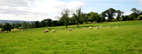
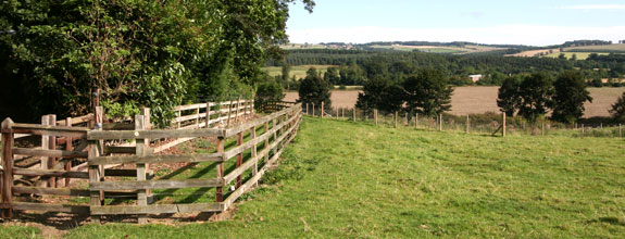
Walks and Cycle Routes around Riding Mill
All walks start in the Old School Playground adjacent to St James church, where there is limited parking. This is used as a thoroughfare so if needing to park please do so considerately. Alternatively, parking is available on Whiteside Bank.
Please observe the country code:
- Guard against all risk of fire
- Fasten all gates
- Keep dogs under proper control
- Keep to paths across farm land
- Avoid damaging fences, hedges and walls
- Leave no litter
- Safeguard water supplies
- Protect wild life, wild plants and trees
- Go carefully on country roads
- Respect the life of the countryside
- Where possible take dog faeces home, or leave in appropriate bins
For more information about walking in Northumberland, visit Walking Nothumberland, which has details of 90 walks in all parts of the county, as well as books and maps. The County Council also provides a useful Rights of Way map for Northumberland online. Details can be found here.
Walk One | Walk Two | Walk Three|Walk Four|Walk Five|Walk Six| Station Walks
NEW CYCLE ROUTES – the Parish Council is working on a series of cycle route leaflets with more information to follow:
** Route 1
Riding Mill Walk One
Walk 1 – Four miles.
- From the Old Playground, turn left and west along Church Lane, past the school, continuing straight ahead up the steep bank to Long Rigg. As the road levels out, turn left (the route is waymarked by a finger post but you will have to look back to see it). Keep following this track to its conclusion.
- At the end of Church Lane track, turn left and head up hill crossing another stile into an open field.
- Head straight up this field crossing another stile into an enclosed track and continue straight uphill until the gradient eases, with High Plains Equestrian Centre on the right.
- Go through a wicket gate and turn right, passing in front of High Plains farm house, heading slightly left across the hardstanding area to a substantial track (the middle one of 3) which crosses a small stream and concludes at a 5 bar gate.
- Turn right over a stile just before the gate into the wood and follow the path ahead, sweeping around to the left and keeping the field boundary dry stone wall to the left.
- Once over the remains of a dry stone wall after a couple of hundred yards, the path becomes a more substantial track.
- Continue ahead through the wood until the track forks and follow the right hand fork downhill, emerging from the trees at the top of two fields.
- Turn right down between the fields keeping the fence on your right and hedge to the left (often wet).
Over a stile, keep the fence on your left then continue downhill heading slightly leftwards to avoid the gulley. - Continue ahead in roughly the same direction for a further 200 yards and when the gradient steepens once again and you will see the Blue Bridge ahead of you.
- Cross the bridge, over a stile and follow the steep rough track ahead up through trees crossing another stile alongside a 5 bar gate near the top of the track to reach the Slaley road by Riding Lea Cottages on the right with a post box mounted int he wall.
- Turning right on to the road, follow this past Beauclerc and keep right, down to the main road at the western edge of the village.
- Cross and follow the main road down in to the village, crossing back by the Wellington Pub, turning right up the small lane opposite the pub car park entrance, over the Pack horse bridges and back to the Old Playground.
To extend walk 1 to six miles:
Following the Church Lane track after leaving Long Rigg (point 1), instead of walking to the end of the track, take the first path on the left (uphill), through an opening with a gate and stile alongside just over a hundred yards before the end of the track.
- Follow this path up the fields, over three stiles, keeping the hedge on the right and ignoring the path leaving to the right, until it emerges onto the Broomley Pit House Road via a ladder stile.
- Turn right once over the stile into the entrance to High Plains and then immediately left crossing another stile and into a field.
- Cross the field keeping the wall on your left over a couple of stiles and into a wood.
- Follow the path straight on through the wood, keeping the stone wall to your left and ignoring criss crossing forestry tracks and unofficial paths, crossing a stone wall via a stile, finally emerging onto a tarmac road.
- Turn right following the road for about 1/4 mile until reaching a marked footpath on the right.
- Cross a stile from the road onto open heathland. The path heads down to the left (indistinct) through the gorse for a couple of hundred yards before heading right (waymarked) before a wire fence, along a more distinct path.
- Keeping the field boundary to your left, the path soon drifts right, by a low way marker. Continue through gorse and heather, until reaching a stile over a stone wall into the wood directly ahead.
- Cross the stile and head down with a stone wall on the left for 30 yards, then on reaching a track turn right and follow this track through the wood straight ahead, ignoring the more distinct track which heads off half right almost immediately.
- On reaching a fork in the track after about 300 yards, double back and downhill, now following the track to the Blue Bridge (point 9 – point 12 above) and back to the village.
Riding Mill Walk Two
Walk 2 – Two miles.
- Leaving the Old Playground by the stone drinking fountain in the south east corner, cross the road (Whiteside) and take the footpath directly opposite up the steep bank.
- Go through the kissing gate at the top into a field and continue straight ahead, keeping Wentworth Grange Nursing Home to the left to the far side of the field.
- Go through a kissing gate, over the A68, through another kissing gate, following the fenced path across the next field, then over a stile and into the wood.
- Follow the path up through the trees, crossing a track and up again until reaching a T-junction in the path. Turn left and east, continuing to follow the path until it exits the trees, then follow the track, right to reach a stile with a dog hole by a low stone building (part of the Riding Mill Pumping Station).
- Cross this stile, following the path to the left around the field perimeter turning right at the wood, over a track and throught the gate and along the edge of a 2nd field, keeping the wall to the left, to emerge onto a single track tarmac lane.
- Turn right following this lane for a hundred yards or so before turning right again by West Broomley Farm and following the (closed) road ahead.
- Go through the gap in the stone wall at the end of the road, turn left and follow the bridleway alongside the A68 before crossing the road by High Shilford Farm (take care – cars are travelling at speed).
- After crossing the A68, follow the waymarked path to the right, once again alongside the main road, which joins the top of Whiteside bank and follow the road back down to the Old Playground.
To extend walk 2 to three and a half miles:
On emerging onto the tarmac track (point 5) turn left.
- Follow the lane left past Roe House Farm, where it becomes a gravel track and keep going gently downhill until reaching a T-junction with a tarmac road. Turn right towards Broomley.
- At the next road junction, turn right and follow the road through Boomley.
- After about 1/4 mile, cross a ladder stile on the right and head across the field ahead keeping the hedge on your right.
- Cross another stile to emerge on to the tarmac lane and continue as before (point 5 – point 8).
To extend walk 2 to five miles:
On reaching Broomley (point 10), turn left down the stony track (marked Byway), past the sewerage plant on the left then almost immediately over a stile on the left and into a field (beware of bullocks in Spring).
- Follow the path across the field, with the pond to your right, dropping down to the right to cross the Smithy Burn via a small bridge.
- Climb the bank the other side, following the path left, through a gate and heading into the trees ahead.
- The path snakes right by a former stile then left, arriving at a clearing with a 3 way signpost.
- Take the path to the right (marked Old Ridley), undulating through the trees, ignoring the path off to the left after a couple of hundred yards. (This path leads down to Stocksfield from where you can catch the bus or train home if you wish.)
- After a small rise, the path passes through a kissing gate and becomes enclosed by a wire fence. Once through a second kissing gate the path starts to descend. On joining a track which comes in from the right, double back uphill to follow this track which takes you back to Broomley. Continue back to the village as before (point 10 – point 12 then point 5 – point 8).
Riding Mill Walk Three
Walk 3 – Three/four miles.
- Leave the Old Playground, crossing Church Lane, down the path and over the Packhorse Bridge keeping the church on your left.
- Continue to the main road, crossing by the Wellington Inn, head left then first right, following the road to the Station and Station Cafe.
- Cross the railway by the footbridge, then proceed under the bridge to the far end of the platform and enter the wood via a kissing gate.
- Follow the permissive path down to the river where it joins the public footpath and turn left heading upstream alongside the river.
- Continue to follow the path through the wood, crossing two small wooden bridges, eventually leaving the wood behind in favour of more open ground.
- The path heads slightly left now to a fence which marks the gravel pit boundary. Continue ahead again, keeping the fence to your left.
- After crossing a dilapidated dry stone wall, the path becomes a grassy track. Continue ahead ignoring gates and paths off to either side.
- Follow the path until the wood opens up to give an excellent view west up the river valley towards Corbridge. This is where the path used to climb up Farnley Scar but it is currently closed following significant flood and erosion damage around the time of Storm Desmond in 2015. After admiring the view and the force of nature return the way you came to point 4 and continue back to the village.
Extension 1: Please do not try to do this walk after heavy rain or when the water levels are high.
Instead of walking up to the railway station, continue along the bank of the river until it joins the mouth of the Riding Burn. Follow this round right then left to the stepping stones. Cross these taking care not to slip (do not attempt to cross if the water in the Burn is high or in spate). Up the steps, then follow the path back to the river and round right to the open section of river bank (a good position to watch river life). Then follow the track steeply up hill to the Broomhaugh ‘Street’. Along this then turn right onto the A695. At the Wellingon Inn follow the path back to the Old Playground.
Extension 2:
Instead of turning right at the A695, cross ahead and follow the narrow road over the railway bridge to a T-junction. Turn left and at the end turn right and follow the path steeply uphill until the path passes through a kissing gate. Continue up the field with the Wentworth Grange Nursing Home on your right. Turn right at the top of the grounds to join the path across the field. Go through another kissing gate (Point 2, Walk 2). Follow the path steeply down to Whiteside, turn right then left into the Old Playground.
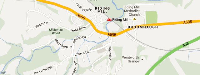
Riding Mill Map
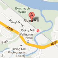
Here is a map of Riding Mill.
You can click on the marker to get directions to, or from, the village.
[google-map-v3 width=”575″ height=”400″ zoom=”15″ maptype=”roadmap” mapalign=”center” directionhint=”true” language=”default” poweredby=”false” maptypecontrol=”true” pancontrol=”true” zoomcontrol=”true” scalecontrol=”true” streetviewcontrol=”true” scrollwheelcontrol=”true” draggable=”true” tiltfourtyfive=”false” addmarkermashupbubble=”false” addmarkermashupbubble=”false” addmarkerlist=”Riding Mill, Northumberland, UK{}1-default.png{}Riding Mill” bubbleautopan=”true” showbike=”false” showtraffic=”false” showpanoramio=”false”]
Millfield Road Update – 10th April 2012

Brief background:
The bridge carrying Millfield Road over the Marchburn is unadopted and owned by the Parish Council (PC), who have undertaken responsibility for its upkeep. However, Northumberland County Council (NCC) has an overall duty to ensure the safety of highway users on all roads, whether adopted or unadopted.
Prompted by a referral of the bridge to the Health & Safety Executive, NCC considered the situation regarding the bridge and imposed a temporary Traffic Regulation Order (TRO) prohibiting use by vehicles greater than 3 tonnes in weight or 2 m in width, whilst the PC considered the longer term future of the bridge. NCC’s Planning and Environment Committee decided to make this TRO permanent in May 2011. It can be revoked only if they are satisfied that the bridge has been strengthened sufficiently to allow the passage of heavier vehicles.
Short-term repairs:
In response to this, the PC commissioned consulting engineers BT Bell to carry out a structural survey on the bridge. This revealed a significant amount of deterioration requiring urgent attention. The PC has authorized BT Bell to oversee the necessary remedial work. They are currently seeking quotations to carry out these works.
We expect this work to begin in June or July (for environmental reasons all work on the bridge piers has to take place during the summer months), and to take about four weeks. While the work is taking place it will be necessary to close the bridge completely to all traffic. We apologise in advance for any inconvenience this may cause.
Unfortunately these repairs will not allow us to remove the current width and weight restrictions on the bridge. The two outer beams supporting the roadway have been severely weakened by corrosion, and in the opinion of BT Bell would not safely support vehicles over 3 tonnes. The purpose of the current repairs is simply to stop the bridge deteriorating to the point where it becomes unsafe for any motor vehicle.
The long-term future of the bridge:
Over the last few months, the PC has also been discussing possible long-term options for the bridge with BT Bell. Four different options have been investigated:.
Option 1: demolish the existing bridge and replace it by a new bridge capable of carrying 44 tonnes. This would cost around £200,000. As before, the PC would be responsible for future maintenance – unless NCC could be persuaded to adopt both the bridge and the adjacent sections of Millfield Road. This would require Millfield Road to be brought up to adoptable standards, at a further cost of about £80,000.
Option 2: provide new balustrades for the bridge, restricting its effective width to 3 m (wide enough to allow passage of ambulances, fire engines and HGVs). This would mean that all traffic using the bridge was carried by the four relatively sound inner beams, but not the two severely corroded outer beams. This would allow the bridge to carry vehicles of up to 7.5 tonnes in safety. The estimated cost of this option is around £24,000; BT Bell are unwilling to say how long the bridge might last if modified in this way. Again, future maintenance would be the responsibility of the PC.
However, discussions with NCC have indicated that the current width restrictions would have to remain, because there is no other way to prevent heavier vehicles from using the bridge. They are not prepared to run the risk of major damage to the bridge or to vehicles that this could cause.
Option 3: close the bridge to all vehicular traffic (though the bridge itself would remain as a public right of way). This should significantly prolong the life of the bridge and, by making Millfield Road a cul-de-sac with “no through road signs”, mitigate the current problem of large vehicles attempting to use it as a through road and having to turn back. This would be the lowest cost option, costing less than £5,000. The PC would have responsibility for future maintenance of the public right of way, though this would probably not be excessive.
Option 4: replace the bridge with a box culvert. This would have similar implications to Option 1. BT Bell have not estimated a price for this option, but their researches suggest that this would be even more expensive to construct than a replacement bridge.
NB: All figures stated are based on costs provided to the PC in 2011.
Conclusions:
In the short term, the PC has already authorized the repairs indicated above. This gives the village time (possibly several years) to reflect on what to do in the longer term. The PC’s view is that there is no benefit in pursuing either option 2 or 4. Option 2 appears to pose insuperable problems over enforcement of weight limits, and Option 4 offers no advantage over Option 1. In the long term, therefore, only two options appear to be realistic, though both have their problems:
Option 1: provide a new bridge capable of carrying all traffic, including heavy goods vehicles, at a cost of around £200,000. The PC could borrow this sum, but the cost of repaying the loan would be substantial and could only be met by making a very significant increase in the precept.
Option 3: close the bridge to vehicular traffic when it is judged to be no longer safe for vehicles. At this point, estimated to be around ten years’ time, the bridge would be restricted to pedestrians.
The decision will affect all of us. Even if you never use a new bridge, you will in effect be paying for it through an increase in your Council Tax, so the decision cannot be taken lightly. No decision about a new bridge will be taken without full consultation with the village. In the meantime, we welcome constructive comments and suggestions from any resident of the village. Please send any comments to our parish clerk Monica Anderton by completing the form below:
Error: Contact form not found.
Village Halls
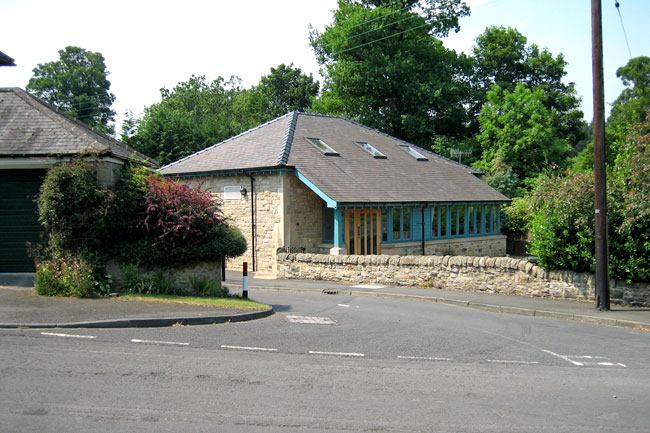

There is now a dedicated website for Riding Mill Village Halls.
Please click here to access the site: https://www.ridingmillvillagehalls.org/

Riding Mill Women’s Institute

In 2015 the Women’s Institute celebrates its Centenary and in Riding Mill we will be having our 86th Birthday.
The Organisation has evolved over these years and still aims to be for women everywhere, inspiring, supporting, educating, and providing an atmosphere of friendship and fun for our 34 members.
We meet at the Parish Hall, Millfield Road, Riding Mill at 7.30pm on the first Thursday of the Month, except August.
Our programme includes speakers, demonstrations, and entertainment with organised outings and fundraising events including Film Shows and Afternoon Tea.
We also have the benefit of taking part in walks, food events, craft days, and quiz and games competitions with other WI’s in Northumberland.
Our meetings are a chance to meet old friends, make new friends and be somewhere to inspire you.
Come along and join us.
Contact – Barbara Nelson, 01434 682739