For a copy of the agenda of Monday’s meeting please click on the link below:
The Council has recently been asked to comment on the Northumberland Local Plan Core Strategy.
Consultation begins Thursday 31st October until Thursday 2nd January 2014.
NCC have arranged a number of local drop-in events where you can find out more information.
Thursday 7th November Prudhoe (Spetchells Centre, Front Street)
Tuesday 19th November Hexham (Prospect House, Hallgate)
Thursday 21st November Ponteland (Memorial Hall)
Thursday 28th November Haltwhistle (Library, Westgate)
Each event will comprise of an exhibition from 3-6pm followed by a discussion session between 6.30-8.30pm
All of the consultation documents are available to view on the NCC website: www.northumberland.gov.uk/corestrategy or by clicking on the links below. Paper copies can be requested from NCC.
If you have issues which you want to raise with the Parish Council regarding the Local Plan Core Strategy please contact Councillor Dunhill.
01 Brief Guide to the Core Strategy Preferred Options Stage 2 Consultation October 2013
02 Core Strategy Preferred Options Stage 2 Consultation Document October 2013
03 Core Strategy Preferred Options Stage 2 Response Form October 2013
04 Interim Sustainability Appraisal – Core Strategy Preferred Options Stage 2 October 2013
05 Habitats Regulations Assessment – Core Strategy Preferred Options October 2013
06 Viability Assessment Consultation Paper – October 2013
07 Draft Revised Statement of Community Involvement October 2013
08 Delivery Document – Scoping Document – October 2013
TO ALL RESIDENTS OF RIDING MILL : October 2010
The Broomhaugh and Riding Parish Council’s position on Millfield Road
1 Background
Over the period 1907 to 1973 the Riding Mill Estate Company (RMEC) bought and developed land in Riding Mill, including Millfield Road, Marchburn Lane, Longrigg and Sandy Bank. Specified obligations and rights went with the properties. One obligation was to make up the road in front of the property and one right was access to all RMEC roads.
In 1973 the RMEC no longer held any land in the village which it could develop and negotiated with the Parish Council (PC) to take over its assets. These consisted of three plots of land which did not appear to be suitable for development; the benefit of covenants; and the above named roads including their 2 bridges. Only the plots of land were seen as having value, and parish residents and the PC raised a sum of money to buy the land. The conveyance of the roads and bridges was made by a separate document for which there was no exchange of money. There was no suggestion that the roads and bridges were “given to benefit the entire village” as has been stated by some. All the roads had longstanding residents’ associations which maintained the roads to the standard the residents saw fit.
2 The Law
The legal advice obtained by the PC was that its ownership of the roads did not imply any obligation to maintain their surface. This is the standard situation in England, as borne out by the briefing document prepared by the House of Commons Library on 3 July 2008, which states:
“The law on the maintenance and adoption of private roads in England and Wales is highly complex. It is contained in sections 203 to 237 (Part XI) of the Highways Act 1980. Briefly, a private or unadopted road is by definition a highway not maintainable at public expense. The local highway authority is therefore under no obligation to pay for its maintenance. Responsibility for the cost of maintaining a private road rests with the frontagers (the owners of properties with frontages on such roads).”
“The highway authority is not responsible for maintaining an unadopted
road although it can intervene under existing legislation to repair it. Responsibility for the cost of maintenance of a private road rests with the frontagers; that is, the owners of properties with frontages on such roads. Even if it is not the frontagers who ‘own’ the road but a third party such as a property company, it is the frontagers who are referred to in the legislation.” (our italics).
The PC is aware that some Millfield Road residents may have obtained conflicting legal advice, but remains convinced of the soundness of its case.
3 And then…..
Sandy Bank residents paid for the upgrade to adoption of Sandy Bank in 1963. Marchburn Lane and Longrigg continue to have associations which manage their respective roads. Millfield Road (MR) had a property owners’ association for 40 years, from the 1960s to 2004, which was then dissolved and its fund of some £14,000 returned to the residents.
In 2001 questions were raised about the strength of MR bridge and the then PC requested the Highways Authority to impose a weight restriction of 7½ tonnes (even though this could not be effectively policed). This was done in 2002.
In 1980 the construction company for Meadow Park had the stretch of unmade road in Church Lane from Church Close to MR upgraded. It has been claimed that this action turned MR into a through road. Responsibility for the link was first laid at the Highways Department, and then the PC and District Council, and they were in turn approached for funding the upgrade of MR to adoption.
After the failure of the approach to the County Council, the PC of 2007 tried to address the issue by arranging a long term interest free loan with the County Council of £220,000 (an average of more than £500 per council taxpayer in the Parish) and sought support of the village to pay for the upgrade of MR and bridge to adoption (to European standards of 40 tonnes).
A referendum was held on the proposal for the village to pay for the upgrade for adoption of the road and bridge using the loan, with the possibility that this would be repaid from selling off the land partly occupied by the double tennis courts; this failed to gain widespread support (199 valid papers returned were in favour and 278 were against). A much less costly alternative was put forward by some parish residents for downgrading the bridge to 3 tonnes and restricting its width so that it could not take large vehicles and would be expected to last for a substantial period. A petition requesting the PC to adopt this solution received 363 elector signatures (nearly half the electorate in the village) within only a few days.
4 The Offer of 2009
After an unsuccessful approach to the District Council in 2008 the PC of 2009 followed through on the second proposal (which would not have permitted adoption). However, after a year’s negotiations with the County Council and the Highways Department, a package was agreed which would allow for adoption of the road alone, provided the bridge was restricted, the road improved and turning heads included. The PC offered to meet the costs for the bridge restriction and to provide a half share of the costs for the upgrade of the road to adoption with the frontagers if that was their wish, and in that package the PC would also accept the cost of 2 frontager shares (for the Parish Hall and the double tennis court land). The offer was turned down by the majority of MR property owners.
5 New Evidence
Research reveals that concerns existed in Millfield Road about traffic from other estate roads before transfer of ownership to the PC and well before the improvement to the link. In 1970 the Millfield Road Property owners’ Association (MRPOA) sought permission from the RMEC to have bollards erected at the south end of MR, closing it to vehicular use from Longrigg. This was turned down. However it establishes that the MRPOA considered the then access from Church Lane was adequate as the sole vehicular access to Longrigg, and that the MRPOA must have considered that there was a proper vehicular link to Church Lane at that time, at least 3 years prior to the transfer of the roads to the PC. In addition, the planning application of 1979 for Meadow Park lodged in the Woodhorn archive shows that there was not a single objection to the improvement to this surface.
6 An analogy
The PC is concerned that many of the arguments advanced in the claims about responsibility for MR have been irrelevant. For example, it has been repeatedly stated that the fact that it is a through road absolves the residents of any responsibility for maintenance. We have been unable to find any legal justification for this point of view. However, we were interested to find a statement in the minutes of Carlisle City Council Executive on 13 September 2004 that Cumbria County Council’s policy on unadopted roads was to contribute up to 50% of the cost of works required to bring the road up to an adoptable standard, provided that the road was a through road (again, our italics). It appears that Riding Mill PC’s offer to pay half the costs of upgrading MR for adoption matched Cumbria County Council’s.
7 Conclusion
We are concerned that the stance taken by certain residents of MR may have encouraged false hopes and discouraged a fair resolution of the issue. Residents who bought before 1979 were able to object to the improvement to the surface of Church Lane and chose not to. Residents who bought after 1979 bought with the full knowledge of the conditions that existed from then to 2010.
The PC acknowledges some of the burdens experienced by residents of MR, and it has sought ways of alleviating them, including offering to pay half the costs of making up the road as well as the entire cost of a Parish Hall car park. But the PC has to maintain a balanced approach when using PC funds (raised through the precept charged on all properties in the village), and it felt that its offer to the frontagers was on the generous side of fair. All 4 former RMEC roads had the same legal status. Other roads in the village are unadopted. Adoption of the road would increase the value of its properties. There are both advantages and disadvantages in having village amenities on your road.
The situation is made doubly difficult for the PC by MR not having an association or representatives to negotiate constructively on its behalf. This was illustrated in July this year when one MR resident expressed safety concerns to the Health and Safety Executive about the bridge on behalf of himself and others in the road and precipitated restrictions being imposed without the consultations promised by the PC. The PC would welcome MR residents re-establishing an association that can represent their interests.
8 Invitation
There are 4 vacant places on the PC. If parishioners are not content with the position of the PC they are welcome to put themselves forward for co-option or election so that they are in a position to advance alternative views.
The PC would in any case welcome new members of all persuasions, ages and interests to contribute towards all its work, especially on improving the amenities and safety in the village. The role is unpaid. There are no perks. It can involve a considerable amount of time, but it is also an opportunity to contribute to the wellbeing of the community.
FOR INFORMATION:
The Northumberland County Council website has undergone some recent changes. It has been redesigned based on customer feedback to make it much easier to complete the tasks that people want to do online.
The Parish Council will put forward three proposals for the Local Transport Plan to be developed by Northumberland County Council. Comments are welcome on the following together with new suggestions by Friday 27th September..
1 “Gated” entrance to the village
2 A 20 mph speed limit through the village
3 Pedestrian Crossing near to the Wellington
4 Footpath, including safe cycle route, along the road to the west of the village to join up with the one at Farnley & on to Corbridge
5 Changes to road layout on A68 at junction with roads to Broomley & Healey i.e. at the top of the hill
6 Safe Cycle route to Stocksfield
7 Resurfacing the footpath at the west end of village between the row of cottages containing the Old Post Office and Riding Grange
8 Repair of the footpath from the Slaley Road grid ref. 005615 to the “Blue Bridge” and ford on the March Burn
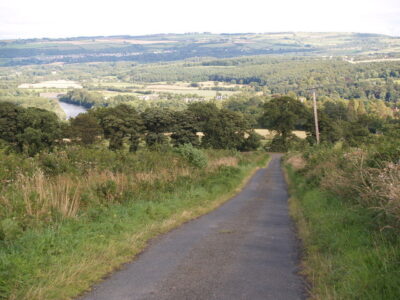
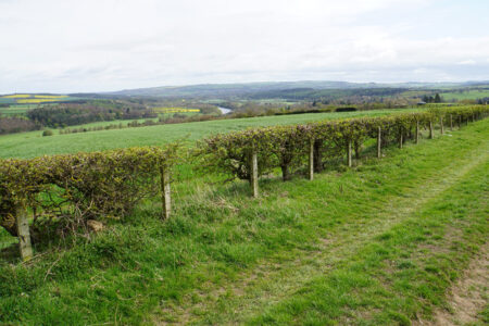
Into the valley of the March Burn
This walk takes in some of the most scenic areas of the quiet countryside in the valley of the March Burn to the south-west of Riding Mill.
7 miles/11 kilometres, 900 feet/270 metres of ascent. Paths and quiet roads. Sometimes muddy.
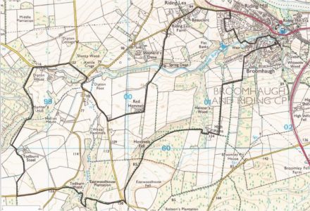
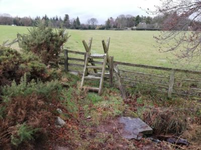
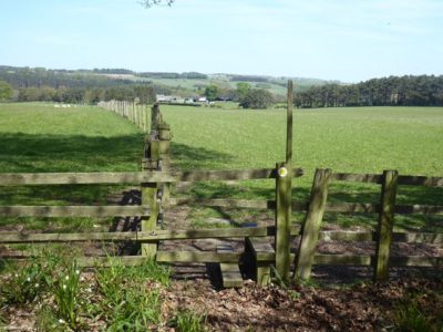
A circular walk via Broomley, Hindley and Healey
Length: 8 miles / 13 km (Time: 3½ hours)
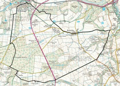
Length: 3.5 miles / 5.5 km