Walks and Cycle Routes around Riding Mill


All walks start in the Old School Playground adjacent to St James church, where there is limited parking. This is used as a thoroughfare so if needing to park please do so considerately.  Alternatively, parking is available on Whiteside Bank.

Please observe the country code:

  • Guard against all risk of fire
  • Fasten all gates
  • Keep dogs under proper control
  • Keep to paths across farm land
  • Avoid damaging fences, hedges and walls
  • Leave no litter
  • Safeguard water supplies
  • Protect wild life, wild plants and trees
  • Go carefully on country roads
  • Respect the life of the countryside
  • Where possible take dog faeces home, or leave in appropriate bins


For more information about walking in Northumberland, visit Walking Nothumberland, which has details of 90 walks in all parts of the county, as well as books and maps.  The County Council also provides a useful Rights of Way map for Northumberland online.  Details can be found here.

Walk One | Walk Two | Walk Three|Walk Four|Walk Five|Walk Six| Station Walks

NEW CYCLE ROUTES – the Parish Council is working on a series of cycle route leaflets with more information to follow:

** Route 1

Riding Mill Walk One

Riding Mill Walk 1

Walk 1 – Four miles.

  1. From the Old Playground, turn left and west along Church Lane, past the school, continuing straight ahead up the steep bank to Long Rigg. As the road levels out, turn left (the route is waymarked by a finger post but you will have to look back to see it).  Keep following this track to its conclusion.
  2. At the end of Church Lane track, turn left and head up hill crossing another stile into an open field.
  3. Head straight up this field crossing another stile into an enclosed track and continue straight uphill until the gradient eases, with High Plains Equestrian Centre on the right.
  4. Go through a wicket gate and turn right, passing in front of High Plains farm house, heading slightly left across the hardstanding area to a substantial track (the middle one of 3) which crosses a small stream and concludes at a 5 bar gate.
  5. Turn right over a stile just before the gate into the wood and follow the path ahead, sweeping around to the left and keeping the field boundary dry stone wall to the left.
  6. Once over the remains of a dry stone wall after a couple of hundred yards, the path becomes a more substantial track.
  7. Continue ahead through the wood until the track forks and follow the right hand fork downhill, emerging from the trees at the top of two fields.
  8. Turn right down between the fields keeping the fence on your right and hedge to the left (often wet).
    Over a stile, keep the fence on your left then continue downhill heading slightly leftwards to avoid the gulley.
  9. Continue ahead in roughly the same direction for a further 200 yards and when the gradient steepens once again and you will see the Blue Bridge ahead of you.
  10. Cross the bridge, over a stile and follow the steep rough track ahead up through trees crossing another stile alongside a 5 bar gate near the top of the track to reach the Slaley road by Riding Lea Cottages on the right with a post box mounted int he wall.
  11. Turning right on to the road, follow this past Beauclerc and keep right, down to the main road at the western edge of the village.
  12. Cross and follow the main road down in to the village, crossing back by the Wellington Pub, turning right up the small lane opposite the pub car park entrance, over the Pack horse bridges and back to the Old Playground.

To extend walk 1 to six miles:
Following the Church Lane track after leaving Long Rigg (point 1), instead of walking to the end of the track, take the first path on the left (uphill), through an opening with a gate and stile alongside just over a hundred yards before the end of the track.

  1.  Follow this path up the fields, over three stiles, keeping the hedge on the right and ignoring the path leaving to the right, until it emerges onto the Broomley Pit House Road via a ladder stile.
  2. Turn right once over the stile into the entrance to High Plains and then immediately left crossing another stile and into a field.
  3. Cross the field keeping the wall on your left over a couple of stiles and into a wood.
  4. Follow the path straight on through the wood, keeping the stone wall to your left and ignoring criss crossing forestry tracks and unofficial paths, crossing a stone wall via a stile, finally emerging onto a tarmac road.
  5. Turn right following the road for about 1/4 mile until reaching a marked footpath on the right.
  6. Cross a stile from the road onto open heathland. The path heads down to the left (indistinct) through the gorse for a couple of hundred yards before heading right (waymarked) before a wire fence, along a more distinct path.
  7. Keeping the field boundary to your left, the path soon drifts right, by a low way marker. Continue through gorse and heather, until reaching a stile over a stone wall into the wood directly ahead.
  8. Cross the stile and head down with a stone wall on the left for 30 yards, then on reaching a track turn right and follow this track through the wood straight ahead, ignoring the more distinct track which heads off half right almost immediately.
  9. On reaching a fork in the track after about 300 yards, double back and downhill, now following the track to the Blue Bridge (point 9 – point 12 above) and back to the village.


Walk Two | Walk Three | Walk Four

Riding Mill Walk Two

Riding Mill Walk 2

Walk 2 – Two miles.

  1. Leaving the Old Playground by the stone drinking fountain in the south east corner, cross the road (Whiteside) and take the footpath directly opposite up the steep bank.
  2. Go through the kissing gate at the top into a field and continue straight ahead, keeping Wentworth Grange Nursing Home to the left to the far side of the field.
  3. Go through a kissing gate, over the A68, through another kissing gate, following the fenced path across the next field, then over a stile and into the wood.
  4. Follow the path up through the trees, crossing a track and up again until reaching a T-junction in the path. Turn left and east, continuing to follow the path until it exits the trees, then follow the track, right to reach a stile with a dog hole by a low stone building (part of the Riding Mill Pumping Station).
  5. Cross this stile, following the path to the left around the field perimeter turning right at the wood, over a track and throught the gate and along the edge of a 2nd field, keeping the wall to the left, to emerge onto a single track tarmac lane.
  6. Turn right following this lane for a hundred yards or so before turning right again by West Broomley Farm and following the (closed) road ahead.
  7. Go through the gap in the stone wall at the end of the road, turn left and follow the bridleway alongside the A68 before crossing the road by High Shilford Farm (take care – cars are travelling at speed).
  8. After crossing the A68, follow the waymarked path to the right, once again alongside the main road, which joins the top of Whiteside bank and follow the road back down to the Old Playground.

To extend walk 2 to three and a half miles:

On emerging onto the tarmac track (point 5) turn left.

  1. Follow the lane left past Roe House Farm, where it becomes a gravel track and keep going gently downhill until reaching a T-junction with a tarmac road. Turn right towards Broomley.
  2. At the next road junction, turn right and follow the road through Boomley.
  3. After about 1/4 mile, cross a ladder stile on the right and head across the field ahead keeping the hedge on your right.
  4. Cross another stile to emerge on to the tarmac lane and continue as before (point 5 – point 8).

To extend walk 2 to five miles:

On reaching Broomley (point 10), turn left down the stony track (marked Byway), past the sewerage plant on the left then almost immediately over a stile on the left and into a field (beware of bullocks in Spring).

  1. Follow the path across the field, with the pond to your right, dropping down to the right to cross the Smithy Burn via a small bridge.
  2. Climb the bank the other side, following the path left, through a gate and heading into the trees ahead.
  3. The path snakes right by a former stile then left, arriving at a clearing with a 3 way signpost.
  4. Take the path to the right (marked Old Ridley), undulating through the trees, ignoring the path off to the left after a couple of hundred yards. (This path leads down to Stocksfield from where you can catch the bus or train home if you wish.)
  5. After a small rise, the path passes through a kissing gate and becomes enclosed by a wire fence. Once through a second kissing gate the path starts to descend. On joining a track which comes in from the right, double back uphill to follow this track which takes you back to Broomley. Continue back to the village as before (point 10 – point 12 then point 5 – point 8).


Walk One | Walk Three | Walk Four

Riding Mill Walk Three

Riding Mill Walk 3

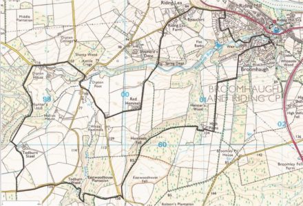
Walk 3 – Three/four miles.

  1. Leave the Old Playground, crossing Church Lane, down the path and over the Packhorse Bridge keeping the church on your left.
  2. Continue to the main road, crossing by the Wellington Inn, head left then first right, following the road to the Station and Station Cafe.
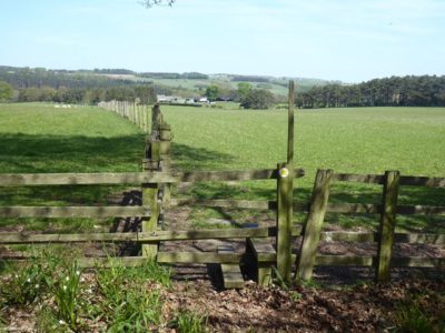
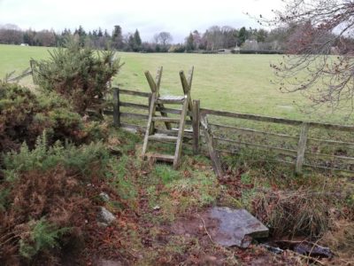
  3. Cross the railway by the footbridge, then proceed under the bridge to the far end of the platform and enter the wood via a kissing gate.
  4. Follow the permissive path down to the river where it joins the public footpath and turn left heading upstream alongside the river.
  5. Continue to follow the path through the wood, crossing two small wooden bridges, eventually leaving the wood behind in favour of more open ground.
  6. The path heads slightly left now to a fence which marks the gravel pit boundary. Continue ahead again, keeping the fence to your left.
  7. After crossing a dilapidated dry stone wall, the path becomes a grassy track. Continue ahead ignoring gates and paths off to either side.
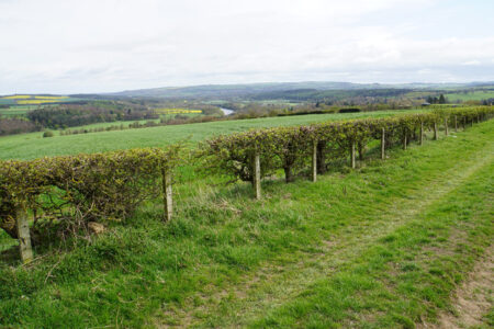
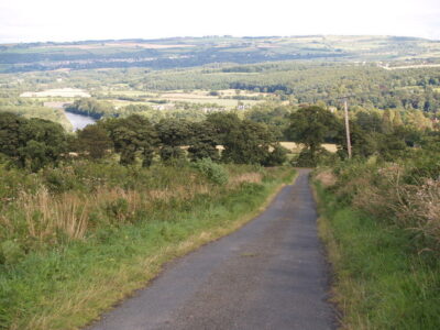
  8. Follow the path until the wood opens up to give an excellent view west up the river valley towards Corbridge.  This is where the path used to climb up Farnley Scar but it is currently closed following significant flood and erosion damage around the time of Storm Desmond in 2015.  After admiring the view and the force of nature return the way you came to point 4 and continue back to the village.

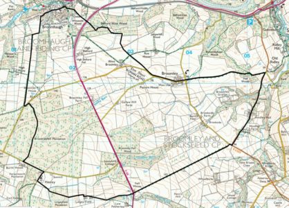
Extension 1: Please do not try to do this walk after heavy rain or when the water levels are high.

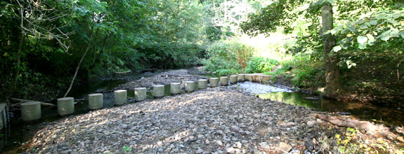
Instead of walking up to the railway station, continue along the bank of the river until it joins the mouth of the Riding Burn.  Follow this round right then left to the stepping stones.  Cross these taking care not to slip (do not attempt to cross if the water in the Burn is high or in spate).  Up the steps, then follow the path back to the river and round right to the open section of river bank (a good position to watch river life).  Then follow the track steeply up hill to the Broomhaugh ‘Street’.  Along this then turn right onto the A695.  At the Wellingon Inn follow the path back to the Old Playground.

Extension 2:

Instead of turning right at the A695, cross ahead and follow the narrow road over the railway bridge to a T-junction.  Turn left and at the end turn right and follow the path steeply uphill until the path passes through a kissing gate.  Continue up the field with the Wentworth Grange Nursing Home on your right.  Turn right at the top of the grounds to join the path across the field.  Go through another kissing gate (Point 2, Walk 2).  Follow the path steeply down to Whiteside, turn right then left into the Old Playground.

Walk One | Walk Two | Walk Four

Riding Mill Walk Four

Into the valley of the March Burn

Footpath to Todburn Steel
Footpath to Todburn Steel farm
cc-by-sa/2.0 – © Oliver Dixon – geograph.org.uk/p/6466308

This walk takes in some of the most scenic areas of the quiet countryside in the valley of the March Burn to the south-west of Riding Mill.

7 miles/11 kilometres, 900 feet/270 metres of ascent. Paths and quiet roads. Sometimes muddy.

  1. Leave the Old Playground heading west along Church Lane and up the hill towards Long Rigg. Where the hill ends, take the public footpath signposted Broomleyfell on the left heading south.
  2. The lane ends at a stile into fields; here turn left and head steeply uphill towards High Plains.
  3. At the hill top, turn right taking the footpath running west into the woods beyond the farmhouse. The level path follows the contour through the wood to a stile with concrete steps across the Parish boundary.
  4. Continue onto Eastwood house Common with extensive views over Slaley Vale and Hexhamshire, following the way-markers until a minor road is reached. Almost directly ahead is a bridle path heading into the narrow valley of the March Burn.  Keep straight ahead once a gate is reached and follow a zig-zag track to a bridge over the burn near the confluence of two streams. Cross the bridge and follow an easier track uphill to the Slaley road.
  5. Turn left along the road for a short distance, then take the Wooley road until a public footpath heads northwards through fields towards Todburn Steel farm. Follow the yellow way-markers, keeping the farm buildings to your right, and over a ladder stile into the southern fringe of Dipton Wood. Here are some fine old oak trees bordering the forest, inhabited in early summer by birds such as the uncommon Pied Flycatcher alongside more common species such as Woodcock and Jay. The path heads down to the stream and then through beech woods to join a minor road west of Dipton House.
  6. Follow the road downhill and at the junction with the Slaley road turn right, downhill to the next junction where you take the left fork sign-posted Healey. Soon the March Burn is crossed by a ford normally dry in summer which can flood, and is avoided by using the adjacent footbridge. The quiet lane ahead is deeply incised into the hillside and features a wide variety of wild flowers. The next right of way is a footpath on the left signposted Riding Lea; follow this to Red Hemmels and then downhill into pastures to cross the March Burn for the third time below Shepherd’s Dene. One last climb follows through mixed woodland fringed by ancient hedgerow trees, before emerging onto the road west of Beauclerc.
  7. The route then heads back to Riding Mill. To avoid the main road, at the junction with the A695 turn right up The Nick and follow Sandy Lane anti-clockwise until a narrow way-marked path at a yellow hydrant sign leads down to the weir and then right onto Marchburn Lane.
  8. Turning left onto Millfield Road, the footpath by the Parish Hall leads to the sixth and final crossing of the March Burn by the old stone bridge, and back to the walk’s starting point.
Into the valley of the March Burn
Parish Online © Crown copyright and database right. All rights reserved (0100053451)


Walk One | Walk Two | Walk Three

Riding Mill Walk Five

Walk 5
Stile on footpath between Healey and Lingey Field / 
cc-by-sa/2.0 – © Clive Nicholson – geograph.org.uk/p/6402017

A circular walk via Broomley, Hindley and Healey

Length: 8 miles / 13 km  (Time: 3½ hours)

  1. Starting from the Old Playground, cross Whiteside Bank and take the footpath that runs past Wentworth Grange to the A68. Cross the road, carrying on past the smallholding and through Shilford Wood. Passing two fields, crossing the Roe House Farm track, and then a third field, join the road towards Broomley. (For those wanting to avoid the road to Broomley, turn left at the Roe House Farm track and follow the track until it meets a road, turn left and follow this minor road to Broomley).
  2. At the far end of Broomley there is a cross roads with the main road turning to the right. Head straight along the unsurfaced byway, which passes open countryside before descending into woodland and reaching the Stocksfield to Ebchester road at Five Ways.
  3. Turn right and follow the road through the hamlet of Hindley. At the end, turn right on to the road signposted Riding Mill and then immediately left at the sign for Wheelbirks Ice Cream Parlour. This minor road becomes a track between high hedges until it reaches the first of several gates. Continue in a straight line, with the field boundary a short distance to the right until the A68 is reached.
  4. Crossing the A68, look for a finger post diagonally to the left. This permissive path bypasses the Low Fotherley farm and joins the public footpath shortly afterwards. Keep the fence to the right until its corner and then look for a ladder stile in the field ahead. Crossing the stile, head for the gate ahead. The track runs for a short distance between stone walls until a second gate. Carry on straight ahead, joining a farm track and passing a farm house. Follow the track as it turns right and then left. When the track turns right again, carry straight on through a gate and across the field, with a fence to the left. At the end, cross the stone wall.
  5. Look for a ride through the woodland and follow this to the end. The path is indistinct and care is needed to dodge the gorse and find the plank bridge over the ditch. A step stile leads into a field. Cross this diagonally to the right to a gate into the next field. Carry straight on to another gate and on to the road at Healey.
  6. Turn right, past the church, and then left at the T junction. Follow the road to Healey Barn and then go through the gate on the right at the finger post.  Follow the path through the plantation until the next road is reached. Turn left and go a short distance to the High Plains road. Taking the first ladder stile on the right, proceed downhill with the hedge to the left. On reaching Church Lane (an unsurfaced track at this point) turn right. Turn right again at Long Rigg and then follow Church Lane at the bottom until the Old Playground is reached.


Route map for Walk five / Parish Online © Crown copyright and database right. All rights reserved (0100053451) 2017

Riding Mill Walk Six

Track near Riding Hills
cc-by-sa/2.0 – © Bill Boaden – geograph.org.uk/p/5401304


A linear walk to Corbridge via Beauclerc, Riding Hills and Prospect Hill

Length:  3.5 miles /  5.5 km

  1. Leave the Old Playground, crossing Church Lane, down the path and over the Packhorse Bridge keeping the church on your left.
  2. Continue to the main road, crossing by the Wellington Inn, turn right and follow the road uphill out of the village.
  3. At the end of the houses, the road to Slaley is uphill to your left.  Cross and follow this road to the small hamlet of Beauclerc.  Watch out for a track on your right leading to Riding Hills (Footpath 508/010).  Follow the path through a 5-bar gate and straight ahead uphill along the field edge, keeping the fence to your right.
  4. Panoramic views soon open up down the Tyne Valley, contrasting the nearby woods and fields against a backdrop of urban Newcastle.  Keep the field boundary to your right and pass through a gate before Riding Hills, turn left and head through a further gate onto the road (please note: the footpath has recently been diverted and no longer passes through the courtyard of the properties at Riding Hills).
  5. Emerging onto the road, turn left and follow it uphill.  A road to your right is soon reached.  Turn right here and follow this road uphill along a ridge of high land, again with stunning views.
  6. When reaching a crossroads, take the road to the right, signposted to Corbridge.  The road swoops downhill past a long-abandoned quarry and zig-zags towards the A695; in a couple of places you can take a footpath shortcut to hasten your descent (lookout for a stone wall stile on your right).
  7. Once at the A695, take the B-road downhill towards Corbridge Station and the village centre.

The Lane coming down from Prospect Hill
cc-by-sa/2.0 – © Clive Nicholson – geograph.org.uk/p/1559224